![](/images/other/stat-length.png)
Le tour des Trois Becs (à l'envers)
Philindy26
User
![Length](/images/other/stat-length.png)
![Max alt](https://static1.geolcdn.com/siteimages/upload/files/1508320355ic_sort_altitude_max_24dp.png)
![Uphill gradient](https://static1.geolcdn.com/siteimages/upload/files/1508320355ic_sort_den_pos_24dp.png)
![Km-Effort](/images/other/stat-length.png)
![Min alt](https://static1.geolcdn.com/siteimages/upload/files/1508320355ic_sort_altitude_min_24dp.png)
![Downhill gradient](https://static1.geolcdn.com/siteimages/upload/files/1508320355ic_sort_den_neg_24dp.png)
![Boucle](https://static1.geolcdn.com/siteimages/upload/files/16400158638029165_repeat_loop_refresh_sync_direction_icon.png)
![Walking](https://static1.geolcdn.com/sitytour/trail-icons/101.png)
3h30
Difficulty : Difficult
![Scan this QR Code to open this trail in the SityTrail application](https://capi.geolives.com/qq0zvz2zws4bq2lad0pu/sitytour/trails/2224827/qr.png?size=200)
FREE GPS app for hiking
About
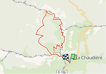
Trail Walking of 10.5 km to be discovered at Auvergne-Rhône-Alpes, Drôme, La Chaudière. This trail is proposed by Philindy26.
Description
Départ du col de La Chaudière (1032m) au parking du Pas de Siara...
Géolocalisation (Google Maps) : https://goo.gl/maps/iVxDrN2vn2PcSPt59 .
Montée au Pas de Siara (1300 m),
Au pas de Siara, se diriger au Virage du Pré de l’Ane (1210 m) et suivre à droite le GR9 par la piste jusqu'à la Fontaine aux Oiseaux (1190 m) et se rendre aux Rochers de la Laveuse (1376 m).
A partir de là, montée sur Roche-Courbe ou La Pelle (1545 m), le Signal (1559 m) et le Veyou, point culminant des Trois Becs à 1589 mètres d'altitude.
Retour par le sentier qui vous ramènera directement au pas de Siara,
Là, direction le parking du col par le sentier de montée…
Positioning
Comments
Trails nearby
![Trail Walking Bourdeaux - Chemin des protestants- Bourdaux - Photo](https://media.geolcdn.com/t/375/260/c9690b91-aa42-47d0-b809-97d643432899.jpg&format=jpg&maxdim=2)
![Walking Walking](https://static1.geolcdn.com/sitytour/trail-icons/101.png)
Walking
![](/images/other/stat-length.png)
![](https://static1.geolcdn.com/siteimages/upload/files/16400158638029165_repeat_loop_refresh_sync_direction_icon.png)
![Trail Walking La Chaudière - Les 3 Becs - Photo](https://media.geolcdn.com/t/375/260/ext.jpg?maxdim=2&url=https%3A%2F%2Fservices.sitytrail.com%2FGeolivesWS%2FDownloadMedia.ashx%3FTrailID%3D218224%26Media%3Dfix__20130901120821.jpg)
![Walking Walking](https://static1.geolcdn.com/sitytour/trail-icons/101.png)
Walking
![](/images/other/stat-length.png)
![](https://static1.geolcdn.com/siteimages/upload/files/16400158638029165_repeat_loop_refresh_sync_direction_icon.png)
![Trail Walking La Chaudière - La chaudiere - chapelle des Sadoux - Photo](https://media.geolcdn.com/t/375/260/fe29fe3e-8696-4fc7-af92-f6d3eeb26877.jpg&format=jpg&maxdim=2)
![Walking Walking](https://static1.geolcdn.com/sitytour/trail-icons/101.png)
Walking
![](/images/other/stat-length.png)
![](https://static1.geolcdn.com/siteimages/upload/files/16400158638029165_repeat_loop_refresh_sync_direction_icon.png)
![Trail Walking Bézaudun-sur-Bîne - 2022-09-26_14h18m42_12295156 - Photo](https://media.geolcdn.com/t/375/260/f11da23a-0048-4e80-a120-e8dd7afb6f22.jpg&format=jpg&maxdim=2)
![Walking Walking](https://static1.geolcdn.com/sitytour/trail-icons/101.png)
Walking
![](/images/other/stat-length.png)
![](https://static1.geolcdn.com/siteimages/upload/files/16400158638029165_repeat_loop_refresh_sync_direction_icon.png)
![Trail Walking La Chaudière - les 3becs et arches - Photo](https://media.geolcdn.com/t/375/260/97464636-1260-4d97-b592-83a9cda2a983.jpg&format=jpg&maxdim=2)
![Walking Walking](https://static1.geolcdn.com/sitytour/trail-icons/101.png)
Walking
![](/images/other/stat-length.png)
![](https://static1.geolcdn.com/siteimages/upload/files/16400158638029165_repeat_loop_refresh_sync_direction_icon.png)
![Trail Walking La Chaudière - les trois becs - Photo](https://media.geolcdn.com/t/375/260/ext.jpg?maxdim=2&url=https%3A%2F%2Fservices.sitytrail.com%2FGeolivesWS%2FDownloadMedia.ashx%3FTrailID%3D997850%26Media%3Dfix__20180701153419.jpg)
![Walking Walking](https://static1.geolcdn.com/sitytour/trail-icons/101.png)
Walking
![](/images/other/stat-length.png)
![](https://static1.geolcdn.com/siteimages/upload/files/16400158638029165_repeat_loop_refresh_sync_direction_icon.png)
![Trail Walking La Chaudière - La chaudière- chapelle des Sadoux - Photo](https://media.geolcdn.com/t/375/260/6819e1ce-f278-49e2-9b64-8d59d930cfa9.jpg&format=jpg&maxdim=2)
![Walking Walking](https://static1.geolcdn.com/sitytour/trail-icons/101.png)
Walking
![](/images/other/stat-length.png)
![](https://static1.geolcdn.com/siteimages/upload/files/16400158638029165_repeat_loop_refresh_sync_direction_icon.png)
![Trail Walking Chastel-Arnaud - montagne de Farraud - Photo](https://media.geolcdn.com/t/375/260/f18555a4-364f-4c22-b353-208a3bb34108.jpg&format=jpg&maxdim=2)
![Walking Walking](https://static1.geolcdn.com/sitytour/trail-icons/101.png)
Walking
![](/images/other/stat-length.png)
![](https://static1.geolcdn.com/siteimages/upload/files/16400158638029165_repeat_loop_refresh_sync_direction_icon.png)
![Trail Walking Aubenasson - saint Michel Aubenasson - Photo](https://media.geolcdn.com/t/375/260/9cfb9e95-478d-41e2-9a6e-6de46d17856a.jpg&format=jpg&maxdim=2)
![Walking Walking](https://static1.geolcdn.com/sitytour/trail-icons/101.png)
Walking
![](/images/other/stat-length.png)
![](https://static1.geolcdn.com/siteimages/upload/files/16400158638029165_repeat_loop_refresh_sync_direction_icon.png)